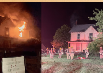
Just hours after twisters swept through the nation’s heartland, injuring more than a dozen people and destroying neighborhoods, forecasters expect another widespread and potentially deadly tornado outbreak throughout the Southern Plains on Saturday.
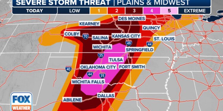
Some 55 million people are at risk of severe weather as the atmosphere recharges Saturday, reaching 1,500 miles from border to border along the Plains, Mississippi Valley, and into the Great Lakes, including many of the areas currently dealing with the aftermath of Friday’s storm.
Tornado Outbreak expected in the Southern Plains with softball-sized hail
On Saturday morning, a series of severe thunderstorms will move from northwestern Texas to western Oklahoma, with large hail and damaging wind as the predominant threats.
A tornado watch, the first of several expected on Saturday, has been issued for sections of Texas and Oklahoma until 1 p.m. CT.
We anticipate widespread severe thunderstorms to develop Saturday afternoon as the environment becomes ideal for several tornadoes and huge hail.
The biggest threat of a tornado outbreak Saturday extends from north Texas to Oklahoma and southeastern Kansas, where NOAA’s Storm Prediction Center has issued a Level 4 out of 5 severe weather risk.
Storms can produce long-track, strong tornadoes with EF-3 strength or higher, large softball-sized hail stones, and wind gusts of more than 75 mph.
Forecasters predict a line of severe thunderstorms to initiate later Saturday evening and move eastward into eastern Oklahoma and north Texas. The more violent elements of the storm line, which will linger into the night, may produce embedded tornadoes and devastating wind gusts of more than 70 mph.
“This is going to be a very dangerous day for so many people, especially if you live in southeastern Kansas, eastern and central Oklahoma, and right into north Texas just across the Red River,” Kendall Smith, a meteorologist with FOX Weather, said.
Severe weather threat extends north into Great Lakes
The FOX Forecast Center expects a warm front to the north to continue from Nebraska to Wisconsin. On Saturday, this front will concentrate on a distinct area of strong to severe storms.
Dangerous Level 3 severe weather dangers exist throughout the Central Plains, including Kansas City, Missouri; Des Moines, Iowa; and Topeka, Kansas.
On Saturday, there is a Level 2 severe weather risk in the Omaha, Nebraska, and Minden, Iowa, communities directly hit by tornadoes on Friday.
Tornadoes and massive golf-ball-sized hail will once again pose the most serious hazards from these storms. Tornadoes with EF-2 strength or higher are possible across southern Nebraska, eastern Kansas, and far western Missouri, encompassing Kansas City and Topeka.
The severe risk extends north into the Great Lakes, affecting parts of Michigan, Illinois, and southern Wisconsin, including Chicago and Milwaukee, which are also at level 2 risk on Saturday.
More daunting weather news: Flash flooding likely in severe weather outbreak zone
If tornadoes, hail, and wind aren’t enough, most of the Southern Plains face major flash floods Saturday night.
As severe thunderstorms become more widespread on Saturday evening, some will be capable of dumping heavy rain at a rate of 2-3 inches per hour.
Thunderstorms can be slow-moving or stall, allowing numerous inches of rain to fall in the same regions, causing considerable flooding.
According to NOAA’s Weather Prediction Center, there is a Level 3 out of 4 flash flood risk from northern Texas through the center of Oklahoma, including Oklahoma City, to southeastern Kansas and southern Missouri.
We expect more thunderstorms in the same area on Sunday, and by the end of the weekend, some locations may receive over 5 inches of rain, with isolated areas receiving more than 8 inches.
No rest for the weary: More severe weather expected Sunday
The risk of severe weather is expected to decrease slightly on Sunday, but there is still a widespread threat of additional storms across the Mississippi Valley. More than 20 million people, from Austin and Dallas in Texas to southeastern Iowa and western Illinois, are under a Level 2 severe weather threat.
Tornadoes, large hail, and damaging wind gusts are once again forecasted, but the storms are not anticipated to be as severe as those experienced on Saturday.
On Monday, the severe weather that has been affecting the nation’s heartland is expected to finally subside.


