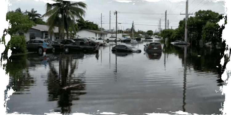
The past few days have seen an unrelenting onslaught of powerful storms drenching much of South Florida, with the forecast for Thursday predicting that the state will continue to be pummeled by massive amounts of rain until Friday. Given the severity of the situation, Florida Governor Ron DeSantis has declared a state of emergency in Broward, Collier, Lee, Miami-Dade, and Sarasota Counties.
Meteorologists have issued a warning that low-lying areas in South Florida could see as much as 8 more inches of rain before the weekend. The current situation in the affected areas is dire, with images showing children navigating through flooded streets in an inflatable raft, adults wading through knee-deep waters in residential areas, and cars stranded and submerged in the middle of roadways. The impending rainfall could exacerbate the situation, making it imperative for residents in the area to remain vigilant and take necessary precautions to ensure their safety.
According to officials, Hallandale Beach, located near Fort Lauderdale, experienced approximately 20 inches of rainfall on Thursday afternoon. Videos shared by residents of Broward County showed cars fully submerged in water. In response, all schools in the county were closed on Thursday and will remain closed on Friday.
On Thursday, forecasters predicted the most severe weather for counties that have already been hit by earlier deluges in the last few days, with flood watches or warnings affecting seven million people in South Florida.
What communities in Florida will be impacted?
On Thursday, the tip of Florida peninsula received a rare flash flood emergency warning due to a tropical disturbance. Even though some parts of South Florida were already hit by heavy rains and flooding earlier in the week, they are now preparing for further rainfall of 4 to 8 inches until Friday, as reported by NEXT Weather meteorologist Lissette Gonzalez on CBS News Miami.
On Thursday morning, the National Weather Service’s meteorologists raised their concern level for excessive rain in the southernmost regions of Florida to “high.” They explained in a bulletin that this upgrade was due to the significant impacts that are anticipated with the next round of heavy rainfall over extremely sensitive areas. This includes the urban corridor in Southeast FL through the I-75 corridor over Alligator Alley.
Alligator Alley, which is named after the reptiles that reside in the area, stretches across the Florida peninsula from Fort Lauderdale on the Atlantic Coast to Naples on the Gulf Coast. According to Florida wildlife officials, alligators and other wildlife may become more visible in flooded neighborhoods after a hurricane or tropical storm. It remains unclear whether the current flooding will prompt them to emerge in a similar manner.
Not only did the governor make an emergency declaration, but Miami-Dade Mayor Daniella Levine Cava, Miami Mayor Francis Suarez, and Fort Lauderdale Mayor Dean Trantalis also issued individual emergency declarations in response to the heavy rainfall and resulting flooding.
When a declaration is made due to severe weather conditions, it activates emergency management protocols that enable authorities at the local or state level, or both, to access necessary resources for quick response. Following the declaration made in Miami, the city has set up sandbag distribution sites for residents to place outside their homes’ doors and windows as a barrier against water. Additionally, nine public parking garages have been opened to provide shelter to car owners residing in flood-prone areas.
CBS News Miami reported that at least 40 rescues were conducted in Dania Beach during Wednesday’s storms, leading to the declaration of a state of emergency for the cities of Dania Beach and Sunny Isles Beach. Streets in Dania Beach were completely flooded, with water levels in some instances reaching as high as a car tire, as seen in photos and videos. Police and fire crews worked tirelessly to conduct the necessary rescues.
As Thursday progressed, several cities and counties prepared themselves for the continuing storms. Miami-Dade and Broward Counties were both under a flood warning that remained in effect until early Friday morning at 4 a.m. ET.
How much rain is Florida forecast to get?
Massive amounts of rainfall have been pouring down on southern Florida due to the current storms. Latest reports reveal that some areas in Miami-Dade and Broward Counties received as much as 20 inches of rain, which is just a little short of the state’s record rainfall total in the past three days, exceeding 2 feet of rain in the Everglades. Meanwhile, along the Gulf Coast, precipitation reports show at least 6 or 7 inches of rainfall in several counties this week, and some counties received as much as 10 or 11 inches.
According to the weather service, Wednesday’s downpour broke new records at several locations, including some in the northern areas, such as Fort Myers and the Winter Haven Regional Airport, which is situated between Tampa Bay and Orlando. Fort Myers received a rainfall of 3.86 inches, surpassing its previous record of 2.14 inches, which was set in 2008. It’s worth noting that Fort Myers has been keeping precipitation records for over a century.
Forecasters predict that the new rainfall totals in and around Fort Myers may exceed the previous record. As of early Thursday afternoon, the area has already received 2 to 4 inches of rain, and an additional 1 to 2 inches are expected.
According to meteorologists, another round of heavy rain is expected to hit southwestern Florida, with the possibility of 6 to 10 inches of precipitation throughout the week. The National Weather Service’s Weather Prediction Center cautioned that certain coastal areas may experience even higher amounts of rainfall, which could extend inland to the peninsula’s interior. The flood watch in the southwest region is set to end at 8 p.m. ET on Thursday.
Communities along almost a 100-mile stretch of Florida’s Gulf Coast, from Tampa Bay through Fort Myers and extending inland for roughly the same distance at certain points in the watch area east of Sarasota, were under a flood watch. On Wednesday, parts of coastal Sarasota County, located just below Tampa Bay, experienced the worst of the Gulf Coast weather. Various spots recorded 6 to 10 inches of rain, with one location in Sarasota reporting almost 11.4 inches of rainfall. Meteorologists provided this rainfall report.
According to forecasters, western Florida has already experienced a considerable amount of rainfall, and they are expecting more. However, they believe that there won’t be widespread flooding due to the precipitation coming in intervals, which will allow the water to drain. The main worry is localized flooding and potential flooding in urban areas. The National Weather Service (NWS) Tampa Bay stated on Tuesday through a social media post that heavy rainfall is predicted throughout the weekend, which could cause minor nuisance flooding in areas with poor drainage and low elevation.
According to data from the National Weather Service, nearly half of all flood-related fatalities in the United States annually are related to vehicles. Therefore, the agency suggests that drivers in the region avoid flooded roads to ensure their safety.
While the southernmost counties of Florida were predicted to receive the most destructive rainfall during Thursday and Friday, meteorologists cautioned that areas closer to the Gulf Coast could still face significant risks of heavy rain and flooding. This is especially true for regions that have already been saturated by previous storms. Experts expressed their greatest concerns for southwestern Florida, where the weather patterns overhead could likely become destabilized due to higher temperatures on Thursday afternoon, resulting in a barrage of showers and thunderstorms.


