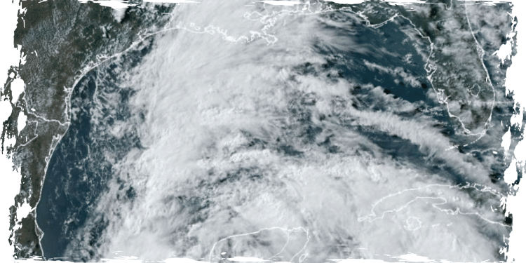
Two tropical storm systems are emerging in the southern Gulf of Mexico and the Atlantic Ocean. These systems have the potential to affect a significant portion of the southern United States, marking the beginning of what experts predict will be an extremely active 2024 Atlantic hurricane season.
South Texas to northeastern Mexico is currently under a tropical storm watch due to the presence of the first named storm of the hurricane season, Tropical Storm Alberto. The storm is predicted to cause heavy flooding, with Texas and Louisiana expected to receive up to 15 inches of rainfall within the next 48 hours.
According to a recent post on X by the National Hurricane Center’s Tropical Analysis and Forecast Branch, a significant disturbance is causing strong winds and heavy rainfall in southern Mexico, Central America, and nearby waters.
The forecast predicts multiple days of intense rain, which could potentially lead to dangerous flooding and flash floods that could endanger lives.
On June 17, 2024, a large disturbance is currently causing heavy rains and gusty winds in Southern Mexico, Central America, and surrounding waters. According to the NHC_TAFB, this disturbance is expected to bring several days of heavy rainfall, which may lead to life-threatening flooding and flash flooding. The NHC_TAFB also shared a link for more information about this weather disturbance.
On Monday afternoon, the National Hurricane Center categorized the storm as Potential Tropical Cyclone One. The Bay of Campeche was experiencing 40 mph winds due to the low-pressure system. A tropical depression is anticipated to form by midweek and is likely to make landfall on Mexico’s northern coast on Thursday.
The National Weather Service issued a warning on Monday afternoon, stating that all attention is on Potential Tropical Cyclone One. Although it hasn’t formed yet, there is a possibility of heavy to excessive rainfall in some parts of the Western Gulf Coast over the next few days.
According to a post by the National Weather Service on X, heavy rainfall is expected this week in southeast Texas, particularly near and along the coast. Additionally, there is a 70% chance of the formation of a tropical depression/storm in the Bay of Campeche.
The National Hurricane Center has reported the formation of a second storm in the Atlantic Ocean, situated east of the Bahamas. It is predicted that this storm will approach the southeast coast of the United States on Thursday or Friday.
AccuWeather senior meteorologist Dan Pydynowski stated that a swift and condensed low-pressure system is on the move and is expected to head towards northeastern Florida or potentially even as far north as southeastern Georgia on Thursday.
There is a 30% likelihood that the current storm in the Atlantic will transform into a tropical depression within the next seven days.
NWS meteorologists have stated that despite the differences in guidance, heavy downpours are expected for the middle to the end of the week. This could lead to the potential for localized flooding concerns to return to certain parts of South Florida.
According to AccuWeather, the Atlantic hurricane season officially began on June 1 and this week’s tropical storms are just the beginning. This year’s hurricane season is predicted to be one of the most active on record.
According to Alex DaSilva, the Lead Hurricane Forecaster at AccuWeather, the 2024 Atlantic hurricane season is expected to see a greater number of tropical storms, hurricanes, major hurricanes, and direct impacts on the United States compared to the average recorded in history.
According to his statement, there is a likelihood of 30 or more storms this year with a probability of 10-15%. He further mentioned that all signs are leading towards an exceptionally active Atlantic Hurricane season in 2024.


